What can the new 3D map do?
The 3D map allows you to display up to 14 categories of buildings divided according to their purposes, such as housing, commerce, sports, recreation or gardens. It can be easily searched by address. Users can change the types of background map or enable shadows to be displayed based on current time. They can view information about multiple buildings at once, using the shift key. Even in a 3D model, buildings can be distinguished by their purposes, or even by floors as in the previous 2D applications.
Beyond the city centre
In two years, information was collected on approximately 110,000 buildings, from which our data specialists calculated gross floor areas, roof type and height using spatial and statistical analyses. So far, they have modelled the historical centre of Brno as part of the 3D solution, and they are now working intensively to extend the map to the outskirts. The pilot 3D map project was presented for the first time in October at an exhibition called “381,346 Spatial Planners” in the Brno’s Urban Centre. Based on the feedback from its users, they want to continuously update the map.
Depth measurements using a ground-penetrating radar should now reveal the condition of the building and whether it can be saved. The test measurement of the first section took place on Tuesday, December 1, and it was organised by the Brno City Chief Architect‘s Office.

The test measurement of the first section includes the first five arches, i.e. about fifty metres from the Malá Amerika building to the south. The results of the first measurement will be available at the beginning of next year. If the measurement method proves successful, we plan to measure the entire route of the viaduct to the bridge over the Svratka River.
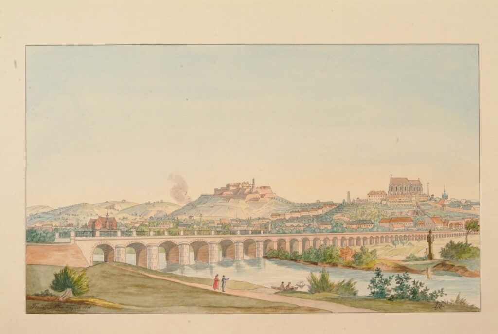
It has not been known for decades whether the original viaduct still exists under the railway embankment and what its condition is. Therefore, we were looking for ways to focus survey the construction under the existing track. If the viaduct can be saved, it will be a significant building and one of the dominants of the new southern district Trnitá. It will serve as a city esplanade from the centre to the Svratka River, similar to the famous High Line in New York.

The Viennese viaduct in Brno was built during 1838 by the Emperor Ferdinand Northern Railway as part of the line between Brno and Vienna. The actual brick viaduct with 72 arches supported a single track and it was a total of 637 metres long. It was followed by a five-arch bridge over the Svratka River, which preserved to this day. Only a few small sections of the original viaduct have been preserved, because during the widening of the track in the 1890s, it was largely buried and hidden in a massive embankment. Fifteen brick arches are preserved under the tracks and accessible from the Malá Amerika warehouse, others are visible in Nové Sady Street.